The Wise Roads Project
Wise Roads, as the name implies, is a project aimed at improving the efficiency of transportation associated with the oil and gas industry. Oil producers and the service companies that support them depend on the use of county and township gravel roads to move commodities and deliver supplies to and from well pads, tank batteries, disposal wells and other industry facilities. However, when inclement weather strikes, local governments impose road restrictions that effectively prohibit the movement of truck traffic until road conditions improve. Restrictions are necessary to protect the integrity of roads and the safety of the traveling public, but industry truckers justifiably complained that at times restrictions were imposed more broadly than necessary.
To address this problem and provide additional, detailed, accurate weather information to county road managers, WDEA (Western Dakota Energy Association) developed Wise Roads in partnership with the North Dakota Agricultural Weather Network (NDAWN) at NDSU. The project will ultimately deploy up to 50 research-grade weather stations throughout the oil-producing counties. Initial siting emphasis focused on the top four producers – Dunn, McKenzie, Mountrail and Williams counties – but stations have also been installed in counties around the periphery of the Bakken core. The goal of Wise Roads is to provide real-time weather information, especially precipitation data, to allow county/township road managers to more precisely identify those roads that require temporary restrictions, and more importantly, exclude those that do not.
Before the project began, weather data was sparse across the Bakken. NDAWN had just eight weather stations in the region. The stations closest to the core of the oil activity were near Ross, Watford City, Dunn Center, Hofflund and Plaza. There were gaps of 40 to 60 miles between some of these sites. There was just one weather station in Dunn and McKenzie Counties, two in Mountrail County and four in Williams County. There are now 15 more stations in McKenzie County, and a total of 40 more stations in the other three counties. Other new stations have been installed in Billings, Bowman, Burke, Divide, Golden Valley, and Stark Counties.
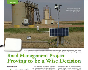
Full-service Wise Roads weather stations are equipped with a high-resolution camera, and are capable of measuring rain, temperature, wind speed and direction, humidity, and soil temperature and moisture.
One other aspect of Wise Roads research is geared toward improving “frost law” policy, the period every spring when weight restrictions are imposed on roads to prevent damage as frost and moisture move out of the roadbed. The project will install soil moisture and temperature probes in the bed of gravel roads in the major oil-producing counties. Data will be collected by WDEA's partner in the project, the Upper Great Plains Transportation Institute (UGPTI), which will use data from the roadbed sensors to better determine when frost or load restrictions need to be placed on roads and when those restrictions can be lifted. The probes will be installed at varying depths on the edge of the road, and compared with data on state highways and probes in ground adjacent to the weather station. Temperature profiles from the roadbed and soil in the gravel roads will be compared to determine if other existing soil temperature sensors in the region and state can be used to estimate road subsurface temperature.
Full-service weather stations cost about $12,000 each, and are being funded by a surcharge on the fees generated through WDEA's LoadPass Permits system for oversize trucks. The Oil & Gas Research Council has supported the project with a matching grant of up to $250,000 for the weather stations, and an additional $60,000 to support a meteorologist who manages the project.